


Colby Canyon offers a scenic route up to both Josephine Peak and Strawberry Peak (most challenging peak in the front range of the San Gabriels). This hike gives you great 360-degree views of the surrounding areas from the top of these mile-high peaks.

Overview:
|
Highlights
Lowlights
|
Hiking Map
While this post is only focusing on the Colby Canyon Trail to either of these peaks, I’ve included more information on this map with other ways to get to these same areas.

Rough Distances of the sections on this map:
- Trailhead to the Saddle: 2.25mi
- Saddle to Josephine Peak: 2.1mi
- Saddle to Strawberry Peak (Mountaineers Route): 2.2mi
- Saddle to Strawberry Peak (via Colby Canyon): 5.75mi
- Saddle to Strawberry Meadow: 3.1mi
- Strawberry Meadow to Eastern Trail: 1.85 mi
- Strawberry Peak to Strawberry Peak Trail (Eastern Trail): 1.25mi
- Strawberry Meadow to Red Box: 4.35 mi
Colby Canyon Trailhead
Colby Canyon Trail to The Saddle
From the parking lot at the trailhead (which is just down the road from Switzer Falls), you’ll start by descending further into the canyon to the left of a creak bed. After a short ways you come to a 30-ft waterfall on your left that will be a tiny stream if it’s recently rained or a dry chute in the summer.

From here you cross a seasonal stream, which isn’t very high and I imagine dries up in the summer and continue into the canyon. The next part of the journey will cross the stream a few more times for about .25mi, and then you’ll start to climb the walls on the right side of the canyon through a series of switch backs.
The trail will continue to weave it’s way along the side of the canyon. Some ares of the trail are carved on a ledge into the side of the canyon with a steep drop off to the steam below.
About 3/4 of the way to the Saddle, you’ll exit the canyon to a “clearing” where you’re surrounded by peaks and can clearly see the last set of switchbacks that lay in front of you. There’s no shade pretty much from here on.

After continuing to follow the switchbacks up the side of the mountain, you’ll reach the Saddle between Josephine and Strawberry Peaks. There’s a cement water tower here to the west, so that you know you’re in the right place.

The trail continues to the right of the water tower, taking a level course around a bump on the ridge to another saddle below.
Here is where the trail then splits to go to either Josephine Peak or Strawberry Peak.
Saddle to Josephine Peak
To get to Josephine Peak, take the trail west from the second Saddle. You’ll walk along this flat saddle to a junction with Josephine Peak Road (this is an old fire road). It’s a wide dirt road that will take you the rest of the way to the summit of Josephine Peak.

Turn right up Josephine Peak Road and follow it for another 1.6 miles. The road stays on the northern side of the mountain and goes through a couple long switchbacks. The last .3 miles of the road will loop you around the top of the peak facing east before you reach the summit.
There’s a helicopter landing pad on the right across from a the trail that goes to the summit. Go left to follow this path past a building and some solar panels. Once you’ve reached the summit, you’ll have a clear 360-degree view.

To get back down, you can either go back the way you came, or you can take Josephine Peak Road all the way back down to the highway as well.
Saddle to Strawberry Peak
There are two ways to get to Strawberry Peak from the Saddle.
Via Colby Canyon – About 6mi
Continue along Colby Canyon Trail past the water tower. This trail is pretty level and stays easy/gentle as it goes along the steep mountainside. The trail goes along the top of the canyon clockwise.

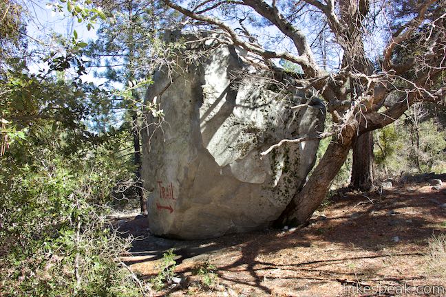
After about 1.3 miles, the trail dips down into some trees, which offer a little bit of shade and crosses a few seasonal creeks. Continue to the forest for a bit and then a switchback to the left takes you down to a flat area with grasses and pine trees. There’s also a fun large boulder with “trail” written on it.
From here it’s about 3/4 mile to the intersection with Strawberry Peak Trail (Strawberry Meadow is just before this intersection if you’re looking for a nice place for lunch). At the intersection, go right on Strawberry Peak Trail.
Continue through the woods, along this trail until you get to Lawlor Saddle. From here, you’ll then loop up to the Peak by taking a right again, coming towards the peak from the East.

The trail is rougher and follows along an undulating ridge. You’ll go over the crest of several ridges, up and down, as you make your way to the summit. The trail becomes temporarily hard to follow as is breaks into several smaller paths. Eventually, the trail comes to a false summit east of the actual peak. To reach the actual summit, you just need to walk across a shallow dip to the actual peak (which has a small bump surrounded by short brush).
Via The mountaineer’s route – About 2.2mi
This goes almost directly from the Saddle to Strawberry Peak along the West Rim Trail. This trail requires class 3 scrambling/climbing.
Shortly after the water tower at the Saddle, as you’re following along Colby Canyon Trail, keep your eye peeled for a short use-trail on the east side of the path very close to the Saddle – this is the Mountaineer’s Route to Strawberry Peak.
You’ll have to go through a quick scramble up to the ridge and then continue around 2 miles to a rugged rock face which looks like the end of the trail…. but it’s not – this is where the climbing begins. Keep on the look out for spray painted arrows on the rocks telling you which direction to go and being your ascent! Up the rock face you go, and after that, it’s a steady steep climb through some shrubbery for the next .6 miles or so.
Eventually, you’ll scramble over a pile of broken rocks and be face to face with Strawberry Peak. This is now the hard part – over the next .25 mile or so you’ll climb up roughly 400ft on a steep class 3 scramble. This part is both exhilarating and terrifying as there appear to be straight-down drops a few times during this climb.
At the end of the scramble, you’ll have reached the summit of Strawberry Peak and take a moment to look around at the 360-degree views and reveal in your accomplishment.
To get back down, you can either go back the way you came (I wouldn’t recommend this, up is hard enough), or you can continue to the east and follow the eastern trail down (if taking the Colby Canyon Route to Strawberry Peak mentioned above, this would be the way you come up to the peak). From here, you can either go right down to Red Box trailhead (about 2.5 mi), or left to Strawberry Meadows and get back on the Colby Canyon Trail.
